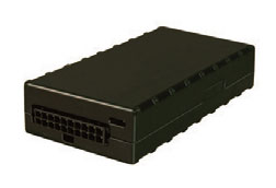
AC2500
 The AC2500 Series is engineered with CDMA or GSM technology to deliver the high reliability needed to help streamline operations, reduce costs associated with service and maintenance of vehicles, improve driver safety and customer response. It is designed as a universal solution for 24/7 visibility and continuous-tracking. Optional features include Driver Identification, Garmin Integration, Starter Disable and Remote Door Unlock
Product Overview
Key Features
- Internal or external cellular and GPS antenna options for easy and covert installation
- High sensitivity GPS
- 20,000 buffered message log
- Dual serial ports
- Garmin® FMI support
- Power management sleep modes
- Automatic, over-the-air configuration and firmware download
Product Differentiators
- Enterprise Class Device for High Reliability
- Optional CDMA technology provided on the largest high-speed wireless network in America -Verizon
- Internal Antennas for easy installation or covert installation
- Covert installation
- Option Garmin L support
- Optional support for PTO
TARGET MARKETS:
The AC2500 Series meets the needs of almost any GPS Fleet Vehicle Tracking requirement.Product Specifications
| RADIO PERFORMANCE | |||
| CDMA Dual-Band | 800/1900 MHz | ||
| GSM/GPRS Quad-Band | 850/900/1800/1900 MHz | ||
| ENVIRONMENTAL | |||
| Operating Temperature | -30º C to 75º C / -22º F to 167º F | ||
| Storage Temperature | -40º C to 85º C / -40º F to 185º F | ||
| Relative Humidity | 95% RH at 50º Non-Condensing | ||
| Drop Spec | U.S. MIL 202G and 810F, SAE J14 | ||
| PHYSICAL SPECIFICATIONS | |||
| Dimensions | 51mm X 102mm X 22mm (2” X 4” X 0.85”) | ||
| Weight | 74g / 2.6 oz (external), 85g / 3 oz (internal) | ||
| GPS FUNCTIONALITY | |||
| Channel | 50 channel GPS (with SBAS, DGPS) | ||
| Connector | Internal or option external SMA - Cellular, SMC - GPS | ||
| Location Accuracy | 2.0 meter CEP (with SBAS) | ||
| Tracking Sensitivity | -160 dBm | ||
| In-vehicle Mapping | NMEA GPS output | ||
| FOTA | Automatic configuration on power-up (PULS™) | ||
| Buffered GPS Message Feature | Yes | ||
| CONNECTORS | |||
| Connection Type | 20-pin Molex-type fused power harness | ||
| Connector | Internal or option external SMA - Cellular, SMC - GPS | ||
| POWER SOURCE | |||
| Operating Voltage | 6 –32 VDC | ||
| Power Consumption | < 3 mA @ 12V | ||
| - | Sleep on Network with SMS | < 10 mA | |
| - | Active Tracking | < 70 mA @ 12V | |
| CERTIFICATIONS | |||
| FCC, CE, IC, PTCRB and Cellular Carrier | |||
Additional Features
Click on any of the features listed below to see other products with that feature.
- Integrates with Driver ID
- 3 year warranty
- Monitor harsh breaking & Acceleration
- Open Service Plans with No Contracts
- 30-Day Money Back Guarantee
- Monitor Ignition On/Off
- Call Phone Number to Hear Vehicle Location (IVR)
- Monitor Up to Three Inputs (in addition to ignition)
- High Sensitivity GPS
- Create Sub-User Accounts
- Group Vehicles
- Reporting Interval (in minutes if not noted)
- 30 sec, 1,2,5 min service plans
- Locate On-Demand (ping at any time)
- Programming API Scripts
- Low Battery Voltage Notification
- “optional” Starter disable
- "optional" Door unlock
- Reconnect Message
- Internal Antennas
- 20,000 stored locations
- Integrates with Garmin devices
- Garmin Integration
Alert Features
Click on any of the alert features listed below to see other products with that feature.
- Posted Speed Alerts
- Send Alerts to Cell Phone
- Power Reconnect Alert
- Input Alerts
- Low Battery Alert
- Harsh Breaking & Acceleration Alerts
- Send Alerts to Email
- Set Idle Time Duration Alerts
- Set Off-Hour Alerts
- Set Stop Duration Alerts
- Set Speed Alerts
- Set Maintenance Alerts
- Set Geofence Alerts
Mapping Features
Click on any of the mapping features listed below to see other products with that feature.
- Displays All Vehicles on One Mapping Page
- Includes Current Location, Heading, and Speed
- View Historical Travel Patterns (breadcrumb)
- One Click Vehicle History
- Dispatch Closest Vehicle
- Create Driving Directions
- Set Up Landmarks
- Set Speed Alerts
- Set Square Geofence (Boundary Alerts)
- Set Poly Geofence (Boundary Alerts)
- Import/Export Landmarks
- Download Historical Data to Excel
- Change Map Icons/Map Labels
- See Street Views
- Display Real-Time Traffic (where available)

